last day on the road, lots of miles. out of camp by 8, home 12 hours later. thats about the limit of what i can take in the saddle. good to be home...
Saturday, January 24, 2009
day #11
Jerry's Flat Rd. follows the Rogue River inland from Gold Beach to Agness, where i stopped for a cup of coffee and a snack. like the Rainbow Resort, this place had a tiny country store with a little patio where the locals hung out. i sat at the picnic table for probably an hour talking to Agness's version of hippie john, the old hippie lady running the store, and her granddaughter. they assured me that Bear Camp Road was totally safe and passable, so i decided to take it, especially since it would lead to the last section of road that i had planned my whole trip around:
as it turned out, the route was much longer, more hazardous, and confusing than i had figured it would be...
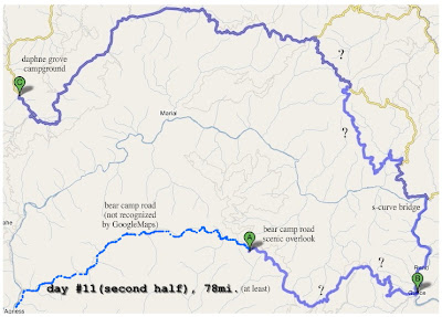
From Agness, Bear Camp Rd. (also designated NFD 23Rd.) immediately climbs up the mountainside from roughly 200' to 3000' at Bobs Garden Mtn. in around 10 miles. this portion of the road, although fully paved and just like any other highway, is not recognized by GoogleMaps; even though the road itself can be found on the site (as well as GoogleEarth) its impossible to highlight it or include it in route calculation...some sort of error, i guess, so i drew it in using a basic editor:
somewhere around point "A" i stopped at a scenic overlook viewpoint and took a bunch of pictures to stitch together as a panorama...
The above shows the entire days ride, "?" represents areas where i was either totally lost and following a compass or just unsure if the road i was on was what my maps suggested. i had actually done a lot preparation beforehand, like checking with the Ranger Station in Gold Beach where they gave me several maps, like the crude pamphlet calling it the Glendale-Powers Bicycle Recreation Area, my Benchmark atlas (with a scale of 1:250,000), and even a GPS; the only reference tool i was missing was an actual BLM or Forest Service map, and i still got lost several times.
In November 2006 Bear Camp Rd. was the focus of national attention with the tragic story of the Kim family. They were coming the other direction and made a wrong turn at one of the routes many confusing unsigned intersections...
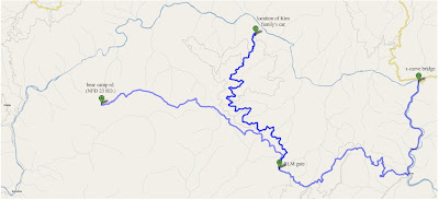
i came from the NW path, down the hill, then stopped here for several minutes trying to figure out which way to go. i think there was even a giant white arrow painted on the road pointing towards the center path, which leads nowhere. its even the most logical-looking road since its the widest, most level choice. nearly every intersection along this route had some kind of bullshit like this, like a signpost with names, arrows, and mileage but it was upside down in a ditch or was illegible because of all the bullet holes. sometimes the tiny signs marking road number (like 34-8-26) would have a couple digits scratched off or the post would be there but the sign itself was missing. every time i studied my maps and GPS,the landscape didnt seem to match what the pages said, and neither showed every road, only some of them, so trying to orient based on a pattern of intersections was useless, as was trying to use the topography as a reference since the GPS didnt show it and my atlas's imaging was too crude on such a tiny scale. i cant remember exactly how it happened, but i think i ended up just rolling into Galice by accident. from there wasnt any trouble, but after crossing a very cool s-curve bridge over the Rogue things got worse.
Back in Galice there was a kiosk with a giant map of the area, so i took a picture of it so that i could inspect it on my cameras LCD screen later in case my other maps werent enough. as it turned out, this was the most useful of all and i used it the most.
After the bridge was where most of my problems were. it was very, very hot and the bike was constantly overheating so i had to stop in the shade and turn it off every 15 minutes or so. when i was near a water source i would fill a cup and spit it out on the motor to try and help it cool down. i guess i wasnt too worried about anything but getting home on time...i had plenty of fuel, drinking water, and food, but it still felt urgent to find my way out sooner than later. Im still not sure exactly what combination of roads i took, so this is just my best guess.
i eventually came across NFD 3348("B" above), which is the name for the Glendale-Powers Byway when youre in the middle of nowhere, and finally had a sign or two. By the time i got this far it was around 5PM, and i knew i had very little useable daylight left, especially at the bottom of the narrow, tree covered canyon i was in. i thought i had finally made it out of the crawling pace of the mountain, but the road hadnt been maintained for cars for so long that huge sections of sunken grade, landslides, wildlife, and/or boulders hid around every blind corner.
i suppose it was fitting that after nearly 2 weeks of perfection id be served a order of bullshit. i gave up for the day at a campground called Daphney Grove on the Coquille River ("C" above) as the sun was setting. it was totally deserted and peaceful, and there was a site with a huge patch of mossy lawn to pitch my tent on, like green carpet. One more day left...
Friday, January 23, 2009
stout grove-gold beach
once i returned to Crescent City, i took Howland Hill Rd. through Jedediah Smith State Park and the area called stout grove. like Fern Canyon, only passenger cars (and motorcycles) are permitted on this route. a narrow, winding gravel road twists through the old growth, often passing between two trees spaced no wider than a few feet...
here, a narrow bridge crosses a tiny creek...the giant stump dwarfs the KLR...
the stout grove trailhead is at the eastern end of howland hill road, and leads to a lollipop route through the old growth...
the trees are huge... beyond words...
dwarfed...
the gravel road eventually emerged from the forest and back into civilization and paved highways on the other side of an old covered bridge, like a kind of gate...
the rest of the day was spent making my way up the coast and back into Oregon. the weather was spectacular, and i took many pictures using photostitch...
unfortunately my decision to head back into California to fern canyon meant i had to cover lots of ground in the last couple days to get home on time, and i was running out of daylight to get to Gold Beach, so i had to keep moving.
it was good to be back in Oregon, i could almost feel it when i crossed the border. and after nearly 200 miles and 10 hours in the saddle i was ready for a soft bed and many beers. i found this ancient motel in Gold Beach called the Oregon Trail Lodge at the north end of town, at the top of the hill overlooking the Rogue River bridge. one of the few remaining old-school motels thats not a shithole, it was exactly what i always look for. privately owned and operated, a real person at the desk, regular keys, and a building so old it doesnt have that cookie-cutter motel room layout. sure, my room smelled like an ashtray rinsed out with listerine, but i had a real door; solid wood with a little window covered by a thin curtain on a rusty curtain rod. i had a real bed with real blankets, not those scratchy rugs and canvas sheets that usually pass for bedding at the franchises. my room even had its own private patio in front and the walls were stained pine or cedar, it was perfect...
tomorrow, into the hills on Jerry's Flat Rd. for my last off-road route of the tour...
fern canyon
fern canyon is formed by Hope Creek on its way to the sea and features 50-foot sheer vertical cliff walls covered in various types of ferns and moss...
the trail starts out normal enough...
...the further in you get, the walls get steeper and closer together...
eventually closing in on all sides; its very other-worldly...
i spent at least a couple hours inside taking dozens of pictures. i happened to be there in the late morning, so there was still a little fog and enough sideways lighting to really bring out the depth of the place..
magical. i guess thats why it was used as a location for The Lost World: Jurassic Park, according to Wikipedia. some day i'd like to camp at gold bluffs for a few days and explore the area some more...
after hiking back to the trailhead, i headed out to the surf and waded into the water, then stretched out on the sand to dry out...
it was such a beautiful day; so isolated and peaceful...perfect...
Sunday, January 18, 2009
day #9-10
for some reason i was so exhausted after riding this day i just got a motel room in Crescent City and went to bed as soon as i got there, around 3 or 4PM. i woke up about 5 hours later and staggered down to the Denny's across the street and had a cheeseburger, then went back to sleep. it was kind of a lost day, i dont remember much about it...
the next day was far more interesting; when i woke up i was really excited to finally get to the real redwoods, and was on my way by 8AM to fern canyon and the prairie creek ranger station, where they had on display a petrified tree trunk that had formed around a trapped elk's antlers...
the road to fern canyon is a 7 mile single-lane gravel road with no outlet, its dead-end at the parking lot/trail head. trailers, RVs, and large trucks are prohibited, and most tourists in regular passenger cars pass it up because of its relative remoteness, so the whole area has a feeling of isolation. davidson road at first climbs up out of the prairie creek valley, then descends through the forest all the way down to the beach...
...where there are 3 stream crossings and the Gold Bluffs campground before reaching the trailhead. the weather was brilliant and i had plenty of time to explore...
day # 8
between Cave Junction and the Oregon Caves NM is an old RV park/campground called Country Hills that has been there for decades, owned and operated by a retired couple that live on-site in the main building at the entrance. i was drawn to its setting on the river and its funky rundown-ness, so i chose a site in the back corner and settled in for the night. i was due after the last couple high mileage days. the place was absolutely deserted and didnt look like anyone had even camped there for a long time; there was moss growing everywhere, firepits were rusty, and everything about it had a kind of ghost-town feel...
the hosts sold beer and firewood so i didnt need to go back out. in fact, they brought it to me, and i had an enormous campfire that night...there was a trail down to the river that led to this amazing little beach, lit up by the sunset:
i may have been eaten alive that night by mosquitos, but it was so peaceful i didnt care. a feeling of true isolation and security is kind of rare and always worth it.
the next morning i went to the Oregon Caves National Monument...it was like taking a tour of an alien world, difficult to explain. unfortunately i didnt have time for the whole thing, so i had to take the early exit...maybe next time...
apparently they were discovered by a trapper who, in 1874, followed his dog after a bear into the caves and became lost, finding his way out by following the sounds of water trickling. eventually the site became an attraction and was officially declared a national monument by President Taft in 1909. the lodge, known as the Chateau, was constructed in 1934 and remains in use today.
in the gift shop, i overheard a ranger describing a couple of sight-seeing routes to the south through the California redwoods, so i asked for myself and learned about Fern Canyon and the petrified trunk with antlers embedded in it. it all sounded too cool to pass up, so i decided to head back across the border...
Subscribe to:
Posts (Atom)