Jerry's Flat Rd. follows the Rogue River inland from Gold Beach to Agness, where i stopped for a cup of coffee and a snack. like the Rainbow Resort, this place had a tiny country store with a little patio where the locals hung out. i sat at the picnic table for probably an hour talking to Agness's version of hippie john, the old hippie lady running the store, and her granddaughter. they assured me that Bear Camp Road was totally safe and passable, so i decided to take it, especially since it would lead to the last section of road that i had planned my whole trip around:

as it turned out, the route was much longer, more hazardous, and confusing than i had figured it would be...
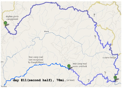
From Agness, Bear Camp Rd. (also designated NFD 23Rd.) immediately climbs up the mountainside from roughly 200' to 3000' at Bobs Garden Mtn. in around 10 miles. this portion of the road, although fully paved and just like any other highway, is not recognized by GoogleMaps; even though the road itself can be found on the site (as well as GoogleEarth) its impossible to highlight it or include it in route calculation...some sort of error, i guess, so i drew it in using a basic editor:

somewhere around point "A" i stopped at a scenic overlook viewpoint and took a bunch of pictures to stitch together as a panorama...


The above shows the entire days ride, "?" represents areas where i was either totally lost and following a compass or just unsure if the road i was on was what my maps suggested. i had actually done a lot preparation beforehand, like checking with the Ranger Station in Gold Beach where they gave me several maps, like the crude pamphlet calling it the Glendale-Powers Bicycle Recreation Area, my Benchmark atlas (with a scale of 1:250,000), and even a GPS; the only reference tool i was missing was an actual BLM or Forest Service map, and i still got lost several times.
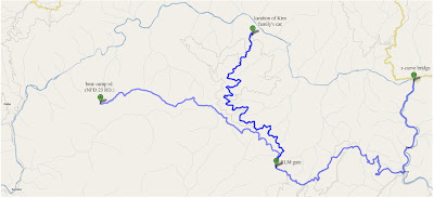
In November 2006 Bear Camp Rd. was the focus of national attention with the tragic story of the Kim family. They were coming the other direction and made a wrong turn at one of the routes many confusing unsigned intersections...
i came from the NW path, down the hill, then stopped here for several minutes trying to figure out which way to go. i think there was even a giant white arrow painted on the road pointing towards the center path, which leads nowhere. its even the most logical-looking road since its the widest, most level choice. nearly every intersection along this route had some kind of bullshit like this, like a signpost with names, arrows, and mileage but it was upside down in a ditch or was illegible because of all the bullet holes. sometimes the tiny signs marking road number (like 34-8-26) would have a couple digits scratched off or the post would be there but the sign itself was missing. every time i studied my maps and GPS,the landscape didnt seem to match what the pages said, and neither showed every road, only some of them, so trying to orient based on a pattern of intersections was useless, as was trying to use the topography as a reference since the GPS didnt show it and my atlas's imaging was too crude on such a tiny scale. i cant remember exactly how it happened, but i think i ended up just rolling into Galice by accident. from there wasnt any trouble, but after crossing a very cool s-curve bridge over the Rogue things got worse.
Back in Galice there was a kiosk with a giant map of the area, so i took a picture of it so that i could inspect it on my cameras LCD screen later in case my other maps werent enough. as it turned out, this was the most useful of all and i used it the most.
After the bridge was where most of my problems were. it was very, very hot and the bike was constantly overheating so i had to stop in the shade and turn it off every 15 minutes or so. when i was near a water source i would fill a cup and spit it out on the motor to try and help it cool down. i guess i wasnt too worried about anything but getting home on time...i had plenty of fuel, drinking water, and food, but it still felt urgent to find my way out sooner than later. Im still not sure exactly what combination of roads i took, so this is just my best guess.
i eventually came across NFD 3348("B" above), which is the name for the Glendale-Powers Byway when youre in the middle of nowhere, and finally had a sign or two. By the time i got this far it was around 5PM, and i knew i had very little useable daylight left, especially at the bottom of the narrow, tree covered canyon i was in. i thought i had finally made it out of the crawling pace of the mountain, but the road hadnt been maintained for cars for so long that huge sections of sunken grade, landslides, wildlife, and/or boulders hid around every blind corner.
i suppose it was fitting that after nearly 2 weeks of perfection id be served a order of bullshit. i gave up for the day at a campground called Daphney Grove on the Coquille River ("C" above) as the sun was setting. it was totally deserted and peaceful, and there was a site with a huge patch of mossy lawn to pitch my tent on, like green carpet. One more day left...


